Image Credit: HomeDepot.com
Table of Contents
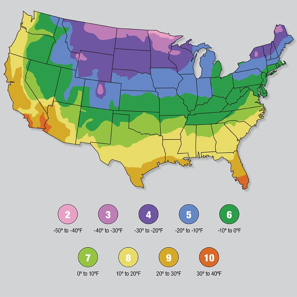
USDA Plant Hardiness Zone is a geographic area defined as having a certain average annual minimum temperature, a factor relevant to the survival of many plants. In some systems other statistics are included in the calculations. The original and most widely used system, developed by the United States Department of Agriculture (USDA) as a rough guide for landscaping and gardening, defines 13 zones by long-term average annual extreme minimum temperatures
The lower the zone number, the colder the average winter temperatures – zone 1 is the coldest zone, and zone 13 is the warmest zone.
The map helps gardeners and growers determine which plants are most likely to thrive in their area. The zones are based on the average annual minimum winter temperature, divided into 10-degree Fahrenheit zones. Each zone is further divided into two subzones, labeled “a” and “b,” which differ by 5 degrees Fahrenheit. For example, zone 7a has an average annual minimum winter temperature of 0 to 5 degrees Fahrenheit, while zone 7b has an average annual minimum winter temperature of 5 to 10 degrees Fahrenheit.
The map is updated every 10-12 years to reflect changes in climate.
Using the USDA Hardiness Zone Map
You can find your plant hardiness zone by entering your ZIP code or city and state on the USDA Plant Hardiness Zone Map website.
| Zone | Cities |
|---|---|
| 1 | Barrow, Alaska; Utqiagvik, Alaska |
| 2 | Coldfoot, Alaska; Eagle, Alaska |
| 3 | Fairbanks, Alaska; Anchorage, Alaska |
| 4 | Juneau, Alaska; Ketchikan, Alaska |
| 5 | Portland, Oregon; Seattle, Washington; Spokane, Washington |
| 6 | Boise, Idaho; Salt Lake City, Utah; Denver, Colorado |
| 7 | Minneapolis, Minnesota; Chicago, Illinois; Detroit, Michigan |
| 8 | New York City, New York; Philadelphia, Pennsylvania; Washington, D.C. |
| 9 | Atlanta, Georgia; Nashville, Tennessee; Charlotte, North Carolina |
| 10 | Miami, Florida; Houston, Texas; Dallas, Texas |
| 11 | Los Angeles, California; San Diego, California; Phoenix, Arizona |
| 12 | San Francisco, California; Sacramento, California; Oakland, California |
| 13 | Honolulu, Hawaii |
Once you know your zone, you can use it to select plants that are best suited for your climate.
The USDA Hardiness Zone Map can be used to help you choose plants that are likely to thrive in your area. When choosing plants, it is important to consider the following factors:
- The plant’s hardiness zone
- The plant’s mature size
- The plant’s sun and shade requirements
- The plant’s water requirements
- The plant’s pest and disease resistance
Plants for Different Hardiness Zones
The following is a list of some popular plants for different hardiness zones:
- Zones 1-3: Hardy shrubs and trees include evergreens such as pines, spruces, and firs; deciduous shrubs such as rhododendrons and mountain laurels; and trees such as maples, oaks, and birches.
- Zones 4-7: Hardy perennials include flowers such as asters, columbines, and daylilies; shrubs such as lilac and hydrangea; and trees such as crabapple and hawthorn.
- Zones 8-10: Tender perennials include flowers such as bougainvillea, hibiscus, and impatiens; shrubs such as oleander and crape myrtle; and trees such as citrus and fig.
Growing Plants in Multiple Hardiness Zones
If you live in an area with multiple hardiness zones, you can grow plants that are hardy in different zones by using a technique called “zone shifting.” Zone shifting involves growing plants in containers that can be moved indoors or to a protected location during the winter. You may refer to our companion plants guide to decide what to grow together.
Note:
- The USDA Hardiness Zone Map is not a perfect system. It is based on average temperatures, so it does not take into account extreme weather events such as cold snaps or heat waves.
- The USDA Hardiness Zone Map is also not a guarantee that a plant will survive in a particular zone. There are other factors that can affect a plant’s survival, such as soil type, drainage, and exposure to sunlight.
- If you are unsure about whether a particular plant will thrive in your area, it is always best to consult with a local nursery or garden center.
- The map does not take into account microclimates, which are small areas that have different climate conditions than the surrounding area. For example, a garden that is located in a valley may experience warmer temperatures than a garden that is located on a hill.
- The map is updated every 10 years, so it is important to check the latest version before making any planting decisions.
Other Hardiness Zone Systems
The USDA Hardiness Zone Map is not the only hardiness zone system in use. Other systems include the Sunset Western Garden Book system and the Royal Horticultural Society (RHS) hardiness zone system.
- The Sunset Western Garden Book system is used in the western United States and Canada. It divides the region into 11 zones, with 1 being the coldest and 11 being the warmest.
- The RHS hardiness zone system is used in the United Kingdom and Ireland. It divides the region into 15 zones, with 1 being the coldest and 15 being the warmest.
